Historical version 14 of King's Cross St Pancras Station (view current version)
-
(streetmap)
(osm)
(gmap)
(bingmap)
(streetview)
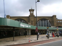
Zone 1 Tube station on the Victoria, Northern (Bank branch), Piccadilly, Circle, Metropolitan, and Hammersmith & City lines. It lies underneath the buildings for the mainline stations of St Pancras (services to Europe, as well as the Midlands and Thameslink services) and King's Cross (services to the north of England and Scotland).
For those thinking of changing between the Victoria and Northern lines here, note that it's almost always better to do this at Euston instead, even if this involves a little doubling back (i.e. if coming from the north end of the Victoria line and changing to go south on the Bank branch of the Northern line), since the Euston interchange is cross-platform whereas the King's Cross one involves struggling through crowds along passages.
Note that the surface structures are in both NW1 (St Pancras) and N1 (King's Cross) postal districts.
See also:
- Wikipedia entry
- Wayback Machine archive of the old OGL entry
- Londonconnections diagram of the entire complex (as of December 2007)
GPS data collected by Kake on a Garmin eTrex, 14 April 2007, and released into the public domain: OSGB 530268, 182956, outside the King's Cross mainline entrance.