Photo:
©
Ewan-M
Historical version 5 of Locale Brick Lane (view current version)
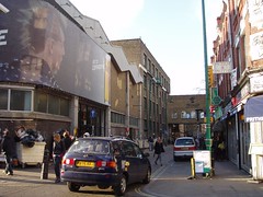
A street stretching from Aldgate in the south to Shoreditch in the north, almost to Columbia Road and its flower market. On the way it takes in Spitalfields, a lot of Bangladeshi curry houses, and the old Truman Brewery (pictured), now converted to a vibrant arts and cultural quarter, with shops, cafes and bars).
Auto-generated list of things on or near Brick Lane (view them on a map):
- Beigel Bake, E1 6SB
- Close-Up Film Centre
- Hookah Lounge, E1 6SB
- Labour And Wait, Shoreditch
- Nude Espresso, E1 6QR
- Pfig
- Pride Of Spitalfields, E1 5LJ
- Rich Mix Cultural Centre
- Shoreditch High Street Station
- Standard Balti House, E1 6QL
- Ten Bells, E1 6LY
- Vegan Yes, E1 6RF
- White Hart, E1 7RA
North: Shoreditch
North-East: Bethnal Green
East: Spitalfields
South-East: Whitechapel South-West: Aldgate
West: Broadgate and Liverpool Street
North-East: Bethnal Green
East: Spitalfields
South-East: Whitechapel South-West: Aldgate
West: Broadgate and Liverpool Street