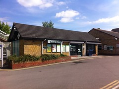
Randomness Guide to London Menu

Blog
Contact
About
Picture of Hackbridge Station
Photo: © bob

Hackbridge Station

Hackbridge Station
  • Address: London Road, SM6 7BJ (streetmap) (osm) (gmap) (bingmap) (streetview)
  • Categories: Rail, Sutton Loop, Thameslink, Zone 4 Stations
  • Locales: Hackbridge, SM6

Zone 4 rail station in Hackbridge, on the Sutton Loop of the Thameslink route. Trains to Sutton, Wimbledon, and central London via Elephant & Castle and Blackfriars.

This station has interesting accessibility. It is step free access to the London-bound platform, and a long steep path to London Road on the other platform. You cannot change platform without leaving the station but you are unlikely to need to. However there is no pavement from the station to the road, you need to walk through a carpark in the roadway. There is now a green man crossing outside the station, making it much easier to cross the road.

See also:

  • National Rail station information
  • Wikipedia entry
of here.

Enter your postcode to show directions to this place:

OS X co-ord: 528578 OS Y co-ord: 165927 (Latitude: 51.377843 Longitude: -0.153912)
Last edited 2023-09-05 12:26:07 (version 9; diff). List all versions.
Randomness Guide to London
Search
  • Find things by location
  • Find things near other things
  • Pub search
  • Food search
  • Other searches
Categories
  • Pubs (map) (random)
  • Restaurants (map) (random)
  • All categories
  • All locales
  • All postal districts
Tools
  • Recent changes
  • Random page
  • Statistics
Help
  • FAQ
  • How to get started
  • How to make links and things
  • Wiki etiquette
This page
  • Show pages linking here
  • List all versions
  • Show diff from previous version
Options
  • Set username/prefs
Page last edited 2023-09-05 12:26:07 (version 9).

Powered by OpenGuides 0.83mod.
Site design adapted from the Creative Commons Licensed “Naturalist” by Darren Hester.

The textual content of this work is licensed under the Creative Commons Attribution 2.0 licence.