Photo:
©
Kake
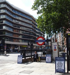
Chancery Lane Station
- High Holborn, WC1V 6DR (streetmap) (osm) (gmap) (bingmap) (streetview)
Zone 1 Tube station on the Central Line.
There are no surface buildings; entry to the station is via one of four (or is it three?) subway entrances arranged around the intersection of High Holborn and Gray's Inn Road.
See also:
GPS data collected by Kake on a Garmin eTrex, 9 March 2007, and released into the public domain: OSGB 531155, 181620, on the corner of the pavement behind the northeast entrance.
OS X co-ord:
531153
OS Y co-ord:
181632
(Latitude:
51.518392
Longitude:
-0.111119)
Last edited 2023-09-05 11:44:01
(version 7;
diff).
List all
versions.