Locale: Kentish Town
| Gospel Oak | Tufnell Pk | Holloway |
| Belsize Pk | Kentish Town | Lower Holloway |
| Chalk Farm | Camden Town | Lower Holloway |
An area in the London Borough of Camden, within postcode district NW5.
The development of the area was as a settlement on the road to Highgate, which became more favoured in the mid-18th century with the coming of improved coach transport. It remained partly rural until the mid-19th century, but all this had gone by the 1870s. Kentish Town Station (and South Kentish Town Station, now closed and at present the site of a Cash Converter store) opened in 1907. The area saw improvements to its run-down conditions in the early-20th century, and there was redevelopment after World War II, which saw the return of the middle-classes.
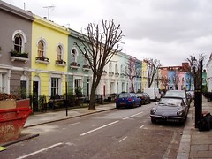
The area's main thoroughfare is Kentish Town Road, whose mix of gastropubs and discount stores perhaps gives a flavour of the different local populations. It also houses the [Forum]? music venue.
Kentish Town borders Belsize Park to the west, Gospel Oak to the north, Tufnell Park to the north-east, Camden Town to the south and Chalk Farm to the south-west.
See also:
The following list is automatically generated (view them on a map):
- Assembly House, NW5 2TG
- Bull And Gate, NW5 2TJ
- Bumblebee Natural Foods, N7 0BT
- Grafton, NW5 3LG
- Junction Tavern, NW5 1AG
- Kami, NW5 2ES
- Kentish Town Station
- Kentish Town West Station
- Lion And Unicorn, NW5 2ED
- Old Eagle, NW1 9LU
- Oxford Tavern, NW5 2AA
- Pineapple, NW5 2NX
- Quinns, NW1 8NY
- Southampton Arms, NW5 1LE
- Tapping The Admiral, NW1 8SU