Photo:
© billy
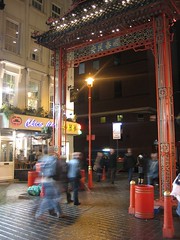
Locale: Chinatown
- Gerrard Street (streetmap) (osm) (gmap) (bingmap) (streetview)
| Soho | Soho | Covent Gdn |
| Picc. Circus | Chinatown | Covent Gdn |
| St James's | Trafalgar Sq | Strand |
London's Chinatown is centred around Gerrard Street, in the City of Westminster. It is shared between W1 and WC2 postal districts.
It's bordered on the north by Shaftesbury Avenue, on the west by Piccadilly Circus, on the south by Leicester Square and on the east by Charing Cross Road.
The nearest Tube stations are Piccadilly Circus (on the Bakerloo and Piccadilly lines) to the west and Leicester Square (on Piccadilly Line and the Northern Line Charing Cross branch) to the east.
See also:
List of places in Chinatown (view them on a map):
- Baozi Inn, WC2H 7JS
- Candy Cafe, W1D 6AX
- Chuan Chuan Xiang, WC2H 7JS
- De Hems, W1D 5BW
- Food House, W1D 5QH
- Gerrard's Corner, W1D 6QW
- Golden Dragon, W1D 6JW
- Golden Gate Cake Shop, W1D 5BR
- Imperial China, WC2H 7BA
- Imperial, WC2H 7BL
- Joy King Lau, WC2H 7BL
- Leicester Square Station
- Lido, W1D 5QF
- Lo's Noodle Factory, W1D 6EZ
- Loon Fung Supermarket, W1D 5QJ
- Manchurian Legends, WC2H 7BE
- New Loon Moon Supermarket, W1D 5PP
- New World, W1D 5PA
- Prince Charles Cinema
- Rasa Sayang, W1D 6AY
- See Woo, WC2H 7BE
- Tokyo Diner, WC2H 7JP
OS X co-ord:
529783
OS Y co-ord:
180860
(Latitude:
51.511771
Longitude:
-0.131137)
Last edited 2023-09-05 12:54:27
(version 15;
diff).
List all
versions.